Attention
Cate has become the ESA Climate Toolbox. This documentation is being discontinued. You can find the documentation on the ESA Climate Toolbox here.
2. About Cate
The name Cate stands for “Climate Analysis Toolbox for ESA” and is a software developed to facilitate processing and analysis of all the data products generated by the ESA Climate Change Initiative Programme (CCI). Cate supports analysis and interactive visualisation of these data products using its software interfaces.
2.1. Interfaces
Cate comprises four major software interfaces:
Cate Software-as-a-Service (SaaS) provides to users access to the Cate software without any installation and configuration. Cate SaaS also provides some computational resources free of charge, however service capacities might be throttled depending on the number of concurrent users logged into the system. In the future, this will be the recommended way to use Cate for most users.
Cate App is a web application that can either use the remote Cate SaaS or a local server.
Attention
The latest version of Cate App is available at: https://cate.climate.esa.int The Cate SaaS cloud service is free to use. User just need to register.
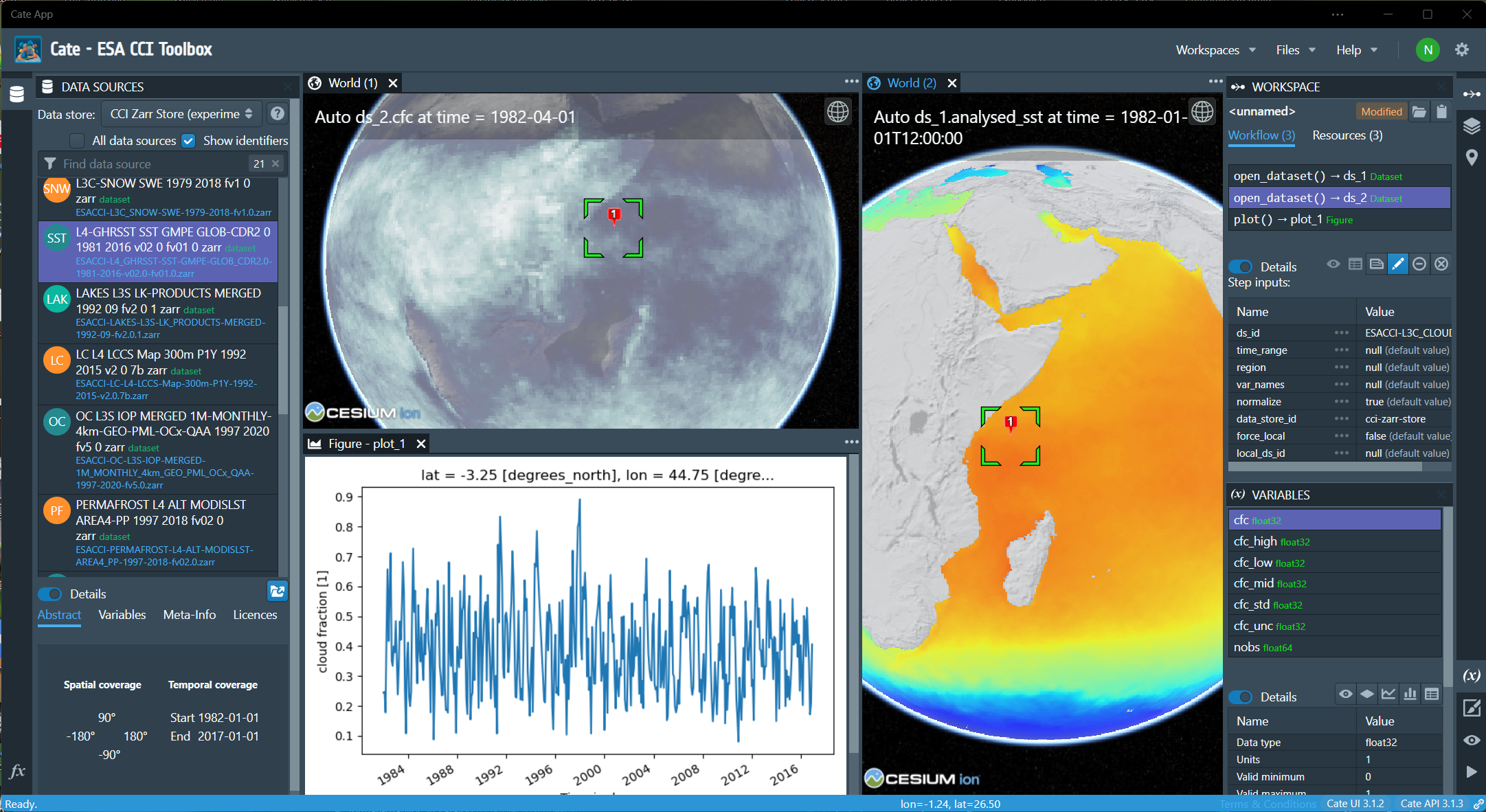
Fig. 2.1 Cate App - the GUI for the CCI Toolbox (desktop version)
The Cate App can also be used with a local Cate WebAPI or any Cate WebAPI service with known URL:
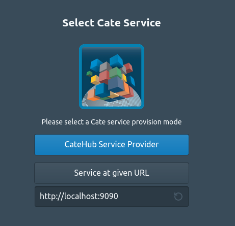
Fig. 2.2 Cate App Login Page
The Cate Command-Line Interface (CLI) from a local Cate installation can be used to access and process data through a command shell or console terminal. Almost all of Cate functionality except interactive visualization is accessible through its CLI when installed locally. The CLI can be used by users who wish to use Cate to process and analyze data, but use their own preferred software for further analysis and visualization. The CLI can also produce static plots as supported by commonly used matplotlib. This CLI is also suited for batch processing scripts for automation.
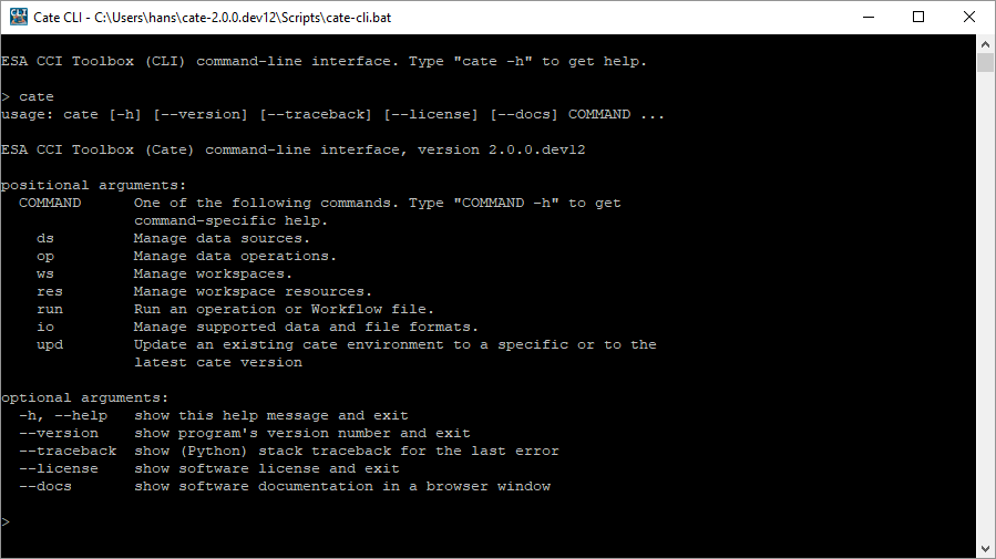
Fig. 2.3 Cate CLI, this is the CLI of the CCI Toolbox
The Cate Python API allows using Cate functions in Python programs and may also be used to extend Cate. Cate is programmed in Python 3.
These interfaces are further described in User Manual.
2.2. Concepts
The Cate software is based on a few simple concepts, which are referred to in all user interfaces. Therefore you should make yourself familiar with them before using Cate.
2.2.1. Data Stores
By default, Cate uses the CCI Open Data Portal (ODP) remote data store which provides access to all published CCI datasets. There is also a local data store, which is used to synchronise remote data or to add any other data sources to Cate 1.
2.2.2. Data Sources
A data store comprises multiple data sources which know each dataset’s unique identifier and other descriptive information about the dataset. Each data source also knows about the available data access protocols, which may be direct file access, file download via HTTP, or access through OPeNDAP, or a Web Coverage Service (WCS).
In Cate’s CLI, cate ds is used to perform numerous dataset-related tasks. Type:
$ cate ds --help
to get an overview of the supported sub-comands.
For example, use:
$ cate ds list
to list available data sources.
In the GUI, the panel DATA SOURCES lets you query and open available data sources.
Note that all remote CCI data source identifiers are prefixed by “esacci.”, for example
esacci.SST.day.L4.SSTdepth.multi-sensor.multi-platform.OSTIA.1-0.r1. Local data source identifiers are
prefixed by “local.”, for example local.SST_NAC_2010.
2.2.3. Datasets
You may open datasets from a data source just by providing the dataset’s identifier. The underlying physical file structure or access protocol remains transparent. That way, Cate can also deal with datasets that don’t fit into your computer’s memory, Cate allows for out-of-core and multi-core processing. However, you can always read datasets directly from your local. e.g. NetCDF files or ESRI Shapefiles.
For Python programmers: it might be interesting for you that Cate does not invent new data structures for representing datasets in memory. Instead, opened datasets are represented by data structures defined by the popular Python packages xarray, pandas, and geopandas:
Gridded and raster datasets (based on NetCDF/CF or OPeNDAP) are represented by xarray.Dataset objects 2. Dataset variables are represented by NumPy-compatible xarray.DataArray objects.
Vector datasets (from ESRI Shapefiles, GeoJSON files) are represented by geopandas.GeoDataFrame objects. Dataset variables are represented by pandas-compatible geopandas.GeoSeries objects.
Tabular data (from CSV, Excel files) are represented by pandas.DataFrame objects.
2.2.4. Functions and Operations
Cate provides numerous I/O, analysis, and processing operations that address typical climate analyses. They are available through all Cate interfaces, the Python API, the CLI, and the GUI.
For Python programmers: Theses operations are usual Python functions. The only difference is that Cate has an operation registry where functions to be published for use through the CLI and GUI are registered. In addition to operations provided by Cate, the Python packages xarray, pandas, and geopandas provide a rich and powerful low-level data processing interface for the datasets opened through Cate.
In Cate’s CLI, cate op is used to perform numerous operation-related tasks. Type:
$ cate op --help
to get an overview of the supported sub-commands. For example, use:
$ cate op list
to list and query available operation.
In the GUI, the panel OPERATIONS lets you query and apply all available operations. Applying an operation creates a new workflow step in the current workspace.
2.2.5. Workflows, Resources, and Workspaces
Using both the CLI and the GUI, users can work in interactive mode, which means that one command creates a certain state which provides a context for another command. In Cate, this can be done without actually storing any data to disk in-between two commands. For example the simple workflow
open dataset ds1
open dataset ds2
get variable v1 of ds1
get variable v2 of ds2
compute v2b which is v2 on the same grid as v1
compute c which is the correlation between v1 and v2b
output c
can be both executed the same way in the CLI and the GUI. Each step generates a new resource,
e.g. ds1, v2. which can serve as input for a subsequent step. Only in the last step, data
processing is actually triggered through the workflow, effectively computing and outputting the current
value of resource c. Currently, Cate workflow steps must refer to a Cate operation.
Later versions of Cate will also support the following step types:
Python expressions with access to Cate Python API, xarray, pandas, geopandas, etc.
Python scripts with access to Cate Python API, xarray, pandas, geopandas, etc.
Any shell executables
Other workflows
Workflows are also saved and reopened as part of a Cate workspace. A Cate workspace refers to a directory in the
user’s file system containing a .cate-workspace sub-directory, where Cate stores workspace-specific
data such as the workspace’s workflow. The workflow is saved as a JSON file within that sub-directory together
with any other files serving as input or output for the workflow. Relative file paths used as operation parameters are
resolved against the current workspace directory. If a workspace is closed, all of its in-memory resources are closed
and released.
The following figure Fig. 2.4 shows the workspace with its contained workflow steps and the associated in-memory resource objects.

Fig. 2.4 Cate’s workspace/workflow concept
In Cate’s CLI, you’ll find all workspace- and resource-related commands by using the cate ws and cate res
commands:
$ cate ws --help
$ cate res --help
Using the CLI run command, workflows can be directly executed when given as a JSON-formatted text file:
$ cate run <my-workflow.json>
More on workflows and its file format can be found in a dedicated chapter Workflows.
In Cate’s GUI, workspace commands are available in the File menu. Furthermore
the panel WORKSPACE lists all available workspace resources and workflow steps, and
the panel VARIABLES lists the variables of a selected workspace resource.
Both provide additional workspace-related commands.
- 1
Currently, only NetCDF files can be used as local data sources. In future releases, we will support other formats such as ESRI Shapefiles and GeoTIFF.
- 2
Currently, only NetCDF and OPeNDAP sources can be represented by
xarray.Datasetobjects. In future releases, we will support other generic formats such as GeoTIFF or HDF.